
By Al Miraq News Desk
Published: August 22, 2026
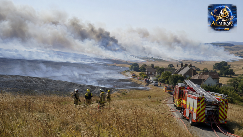
The UK wildfires 2026 season has emerged as one of the most damaging in recent years, with more than 18,800 hectares of land reported burned across England and Wales by this point in the year.
An analysis using satellite-based fire detection, additional satellite imagery and other data has identified widespread wildfire activity across the country. The scale of land affected is particularly significant because the total is reportedly more than four times the size of Oxford.
The findings indicate that the problem is not simply the number of fires. In an important change from previous years, there have reportedly been fewer individual fires than in the same period last year, while the fires that have occurred have burned substantially larger areas.
That pattern is raising concerns among wildfire specialists about the UK’s ability to prepare for increasingly destructive fire seasons.
The situation has been particularly serious in Wales, where six of the ten largest fires identified during the year have reportedly occurred.
UK Wildfires 2026 Have Burned More Than 18,800 Hectares
Satellite technology has become an important tool for monitoring wildfires because sensors can identify heat signatures from fires across large areas.
The analysis presented by Sky News combined satellite fire-detection information with other satellite imagery and data sources to map wildfire activity throughout England and Wales.
The resulting picture shows fires occurring across multiple parts of the country rather than being concentrated in one isolated region.
More than 18,800 hectares of land have reportedly burned across England and Wales so far in 2026. The figure represents a record for this point in the year based on the analysis presented.
For perspective, the affected area is more than four times the size of Oxford.
The figure does not mean that every burned area was destroyed by a single major wildfire. Instead, it represents the cumulative area affected by numerous fires of different sizes and intensities.
This distinction is important because the number of fires alone does not necessarily reveal how serious a wildfire season has become.
Satellite Data Shows the Scale of the Problem
Satellite imagery provides emergency authorities, researchers and journalists with a way to examine fires across large geographical areas.
The data can help identify the location and approximate extent of burned land, while higher-resolution imagery can show how fires have affected nearby communities, roads and other infrastructure.
In the case of the 2026 wildfire season, the analysis suggests that large fires have become a more important part of the overall picture.
That is significant because a relatively small number of extremely large fires can cause more environmental and economic damage than hundreds of smaller incidents.
Wales Accounts for Several of the UK’s Largest Fires
Wales has been one of the most heavily affected areas during the current wildfire season.
According to the analysis, six of the ten largest fires recorded during the year have been in Wales.
South Wales has experienced particularly notable wildfire activity, including large fires around areas such as Talygarnedd Reservoir and Blaenavon.
The concentration of major fires in Wales highlights the challenges faced by rural and semi-rural communities where large areas of vegetation can provide fuel for rapidly spreading flames.
The geography of some parts of Wales can also make firefighting more complicated. Fires in open countryside, grassland and other difficult terrain may require emergency crews to work across large areas while dealing with changing wind and weather conditions.
19 Fires Reportedly Verified in South Wales
The analysis identified 19 separate wildfire incidents in the South Wales area during a 30-day period.
Not all of those incidents were necessarily among the country’s largest fires. However, their frequency demonstrates the broader scale of wildfire activity in the region.
The repeated emergence of fires can put pressure on emergency services, particularly when several incidents occur at the same time.
It can also make prevention and early intervention increasingly important.
A wildfire that is contained quickly may have a limited impact. A fire that grows rapidly before firefighters can establish control can spread across hundreds or even thousands of hectares.
The Human Cost: When Wildfires Reach Residential Areas
The size of a wildfire is only one measure of its impact.
A comparatively smaller fire can become far more dangerous when it reaches homes, businesses or other populated areas.
This was demonstrated by a wildfire in Stalybridge, where the fire reportedly affected 38 houses.
Nineteen homes were destroyed, while seven of the affected properties were located along one street.
The incident illustrates why wildfire risk cannot be assessed solely by measuring burned land.
A fire in a remote area may burn a large amount of vegetation without directly threatening people. A smaller blaze near a residential community can pose a much more immediate danger.
Satellite Images Reveal the Extent of the Stalybridge Fire
Satellite imagery captured around the time of the Stalybridge incident provides an indication of how quickly the fire affected the surrounding area.
One satellite image was taken at approximately 12:48 on August 13, with the fire reportedly being reported about an hour later.
Imagery from the following day showed the extent of the burned ground around the affected residential area.
The darkened landscape visible in satellite imagery demonstrates how fire can transform large sections of vegetation in a relatively short period.
For residents, however, the consequences are measured in homes, possessions, disruption and the loss of a sense of security.
The incident also demonstrates the importance of early warning systems and rapid emergency response when fires develop close to populated areas.
Wildfires Are Also Disrupting Critical Infrastructure
The consequences of the 2026 fires have extended beyond homes and farmland.
The New Forest experienced a significant wildfire that also affected transportation infrastructure.
A major route used by tourists was reportedly closed by National Highways in mid-August because of the fire.
Road closures are an important part of wildfire management because authorities may need to protect motorists from smoke, flames, falling trees or other hazards.
However, closures can also create economic disruption.
The New Forest is a major tourist destination, meaning that disruption to transportation routes can affect visitors, local businesses and communities that depend on tourism.
The wider lesson is that the impact of wildfires can extend far beyond the immediate area burned by flames.
Why Are Fewer Fires Causing More Damage?
One of the most important findings from the 2026 analysis is the apparent change in the relationship between the number of fires and the amount of land burned.
The analysis indicates that there have been only about half as many fires this year as during the comparable period last year.
Despite that reduction, substantially more land has been burned.
This suggests that the most significant factor is not simply how many fires start, but how quickly and extensively individual fires spread.
When vegetation becomes extremely dry, a fire can move rapidly through available fuel.
Under difficult conditions, firefighters may face a much harder task in stopping a fire before it becomes a large-scale incident.
Large Fires Are Becoming More Significant
Historical comparisons covering 2018 to 2024 show that the number of fires alone does not fully capture the changing wildfire picture.
The analysis indicates that while the overall number of fires has generally declined compared with earlier years, the number of large fires has increased in significance.
That distinction is crucial.
A country can experience fewer fires overall while simultaneously facing a greater threat from the fires that do occur.
Large wildfires consume more land, require greater firefighting resources and can threaten communities and infrastructure across a wider area.
They may also continue burning for longer periods, depending on weather and terrain.
How 2026 Compares With Previous Years
The comparison between recent years and 2026 is particularly striking.
Average annual burned area from 2018 through 2024 provides a historical baseline for England and Wales. The analysis places 2025 significantly above that historical level.
The 2026 figure has now reportedly surpassed the amount of land burned at the same point in the previous year.
This means that the current wildfire season is not simply another year of isolated incidents.
It is developing against a broader pattern in which exceptionally large fires appear to be contributing an increasing share of the total area affected.
However, historical comparisons should be interpreted carefully. Wildfire statistics can depend on the methods used to detect and measure fires, the geographical area included and the period being compared.
Satellite-based measurements can provide valuable large-scale information, but they should be considered alongside official emergency-service and government data.
Dry Conditions Can Turn Vegetation Into Fire Fuel
Wildfires require fuel, heat and suitable weather conditions to spread.
Extended dry periods can remove moisture from grass, vegetation and other combustible material.
Once vegetation becomes sufficiently dry, a fire can spread much faster than it would under wetter conditions.
Wind can make the situation even more difficult by carrying embers ahead of the main fire and allowing flames to move rapidly across open terrain.
The analysis of the 2026 season points to unusually dry conditions as a major factor behind the amount of land being burned.
This helps explain why fewer fires can still produce a larger burned area.
The Growing Challenge for Emergency Services
Large wildfires create significant demands on firefighters and other emergency responders.
Crews may have to protect homes while simultaneously attempting to prevent flames from spreading into additional areas.
When several fires occur across different parts of a country, emergency services must also manage limited resources across multiple incidents.
The challenge becomes more complicated when fires occur in remote terrain, where access can be difficult and firefighting operations can take longer.
Large incidents may require extensive coordination between local authorities, fire and rescue services, police, road authorities and other agencies.
Preparing for Future UK Wildfire Seasons
The current experience has renewed questions about how Britain prepares for wildfire risk.
Craig Hope, described in the analysis as a National Resilience Wildfire Capability Advisor, warned that failure to improve preparedness could result in significantly greater property losses and potentially loss of life.
His warning reflects a wider concern: wildfire preparedness cannot begin only after flames are visible.
Prevention, vegetation management, public awareness, emergency planning and early detection can all play a role in reducing the consequences of major fires.
Communities located near areas of high vegetation or open countryside may also need clear evacuation and emergency communication plans.
Early Detection Could Become Increasingly Important
Satellite monitoring offers one potential tool for detecting fires over large areas.
The technology can help identify heat signatures and provide an overview of where fires are developing.
Combined with ground-based observations, emergency calls and aerial imagery, satellite data can improve situational awareness.
The ability to identify a fire quickly can be especially important when conditions are dry and windy.
The earlier emergency authorities know about a rapidly developing fire, the greater the opportunity to contain it before it threatens homes or critical infrastructure.
What the 2026 Wildfire Season Means for Britain
The most significant lesson from the UK wildfires 2026 season may be that counting fires is no longer enough.
The reported decline in the overall number of incidents compared with the previous year could initially appear encouraging.
But the record amount of land burned tells a different story.
The combination of fewer fires and greater damage suggests that the most destructive incidents are becoming increasingly important in determining the overall impact of a wildfire season.
The destruction of homes in Stalybridge and disruption to major transport routes in the New Forest also demonstrate that wildfire risk is not limited to remote countryside.
Communities, infrastructure and local economies can all be affected.
A Warning for Future Summers
The UK’s current wildfire experience raises an important question about whether extreme fire seasons could become a recurring challenge.
No single wildfire season can by itself establish a long-term trend, and the causes of individual fires can vary.
Nevertheless, the scale of the area burned in 2026 and the apparent growth in the contribution made by large fires provide a serious warning for emergency planners.
Preparing for future wildfire seasons will require accurate monitoring, effective emergency response and greater public awareness.
It will also require authorities to consider how changing environmental conditions may affect the probability and intensity of future fires.
Conclusion
The UK wildfires 2026 season has already become a major national concern, with more than 18,800 hectares reportedly burned across England and Wales by this point in the year.
Wales has accounted for several of the largest incidents, while fires such as the blaze in Stalybridge demonstrate the potentially devastating consequences when flames reach residential communities. The New Forest fire also shows how wildfire disruption can extend to major roads and tourism.
Perhaps most importantly, the available analysis suggests that the UK is experiencing a shift in the nature of wildfire risk: fewer fires can still produce greater destruction when individual incidents spread across much larger areas.
The immediate priority is protecting people, homes and critical infrastructure. Over the longer term, the experience of 2026 strengthens the case for improved wildfire preparedness, early detection and resilience planning.
Whether this summer proves to be an exceptional outlier or part of a broader pattern will require further data and analysis. But the scale of the damage already recorded offers a clear warning: Britain’s approach to wildfire preparedness may need to evolve before the next major fire season arrives.
Al Miraq — Beyond the Headlines.